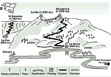
Recuenco (1,239 metres) is the highest peak in Valderejo Nature Reserve. It rises up in the far west of Valdegovía and looks out over the Losa Valley.
Recuenco (1,239 metres) is the highest and most westerly peak of those circling the Valderejo Valley, declared a Nature Reserve in 1992. The others are Arrayuelas (1,128 m) and Vallegrull (1,226 m), but in contrast with these Recuenco shows smooth curves covered in vegetation, making it accessible from many points. Those wishing to scale it generally start out from either the abandoned village of La Hoz (925 m), part of the protected park area, or from the pass known as La Horca de Lerón (902 m), which separates Valdegovía from the Losa Valley. A third option, longer and with a greater difference in levels, starts out from San Pantaleón de Losa .
The second option starting in Burgos province is free from the limitations that apply when climbing it from within the Reserve. It begins at the heights of La Horca, after taking a left turn off the road between San Pantaleón and Tobalina. The route is obvious once you reach the pass, a popular place for hunters and mushroomers during the season.
The wide ridge of Recuenco, covered with holm oaks and pines, appears on the right. During the first stretch there is an open space split into two by a wire fence and separated from the road by a stone wall. It makes more sense to climb over the wall and cross the pasture than to face the wire. This is the starting point for a 4x4 trail that you have to follow right up to the summit.
The trail starts off gently over open country, then becomes tougher with steep stretches as it enters the trees and scrub. You will come across herds of cattle and horses which graze freely here and, if an early start is made, possibly roe deer and other wild creatures as well.
The trail starts to ease off and face south-west, then reaches a level patch at 1,115 m with Bóveda almost within sight (40 minutes). This spot, in the hollow of the twin peaks of Recuenco and Lerón, is an open area covered with heathers and a few huge, solitary beeches, the remains of a wood from an earlier age that once covered these slopes. There are two choices here, to climb to the top either on or off the path (to the right). Following the path is more comfortable and takes a shade over an hour.
A large sign tells visitors that they are on the boundary of the Reserve. The Recuenco is on the left on the edge of a rocky and open plateau with a few scattered beeches. A rather vague but trouble-free path leads up to the highest point of Valderejo (1h15). At the peak of Recuenco are a survey point and a small cairn built in 1972 in memory of J. Torquemada. There are superb views over Vallegrull, the Sierra de Arcena, the La Peña mountains and the peaks of Tobalina and Losa, with Vienda opposite.
fter a slight descent, an imprecise footpath heads on to Lerón (1h30). There is no marker, but the views of Valdegovía are excellent nonetheless. The way down is the same as the way up, as far as the hillock with the sign (1h40). Here at the large white boundary post a decision is needed: bear left to follow the route down towards the San Pantaleón valley, or return along the trail to La Horca. Total time 2.20 hours.
Recuenco (1,239 m) and Lerón (1,235 m).
Mountains in the province of Alava at the westerly limit of Valderejo Nature Reserve with the Losa Valley (Burgos).
None. The route climbs gently upwards, first on a trail and then across pastureland up to the flattish summit area.
340 metres from La Horca Pass; 300 m from La Hoz, and 610 m from San Pantaleón de Losa.
Restaurants in Lalastra, Villanueva de Valdegovía, San Millán, Espejo and Quincoces de Yuso. Service station at the Losa Valley crossroads.
Map 20-7 (110) edited by the Army Geographical Service (Servicio Geográfico del Ejército) and map B-11 covering Valdegovía and Losa from Javier Malo.